By: Jennifer Jun and Brian Hart
May 16, 2024
In the desolate and inhospitable Himalayas, China is constructing and expanding hundreds of “xiaokang” (小康) villages along its hotly disputed border with India.1 These villages, often accompanied by military and dual-use infrastructure, are an important “gray zone” tool enabling China to assert and defend its claims near disputed areas. Commercial satellite images provide a glimpse into China’s activities and show that China is making rapid and significant progress on these border villages despite the harsh environment.
In July 2017, the government of China’s Tibet Autonomous Region announced plans to construct hundreds of border villages and accompanying infrastructure as part of a major push to develop China’s remote border regions. Between 2018 and 2022, the region reportedly built 624 villages, and work has continued on additional villages. Many of these are clustered along the eastern sector of the Line of Actual Control (LAC), the de facto border separating China and India. The eastern sector borders Arunachal Pradesh, a state administered by India but largely claimed by China as “South Tibet” (藏南).
Capturing high-resolution satellite imagery in this region is challenging due to heavy cloud cover, but images from recent months have enabled the analysis of four locations within a small 65 square kilometer (km2) area. These locations—Zhuangnan, Majiduncun, Yarao, and Kuiqiongmen—were chosen to represent different development phases and types, including military, civilian, and dual-use infrastructure. Together, these sites serve as a microcosm of developments underway along much of the 3,500-km border.

Click to enlarge.
Expanded Likely Military Complex at Zhuangnan
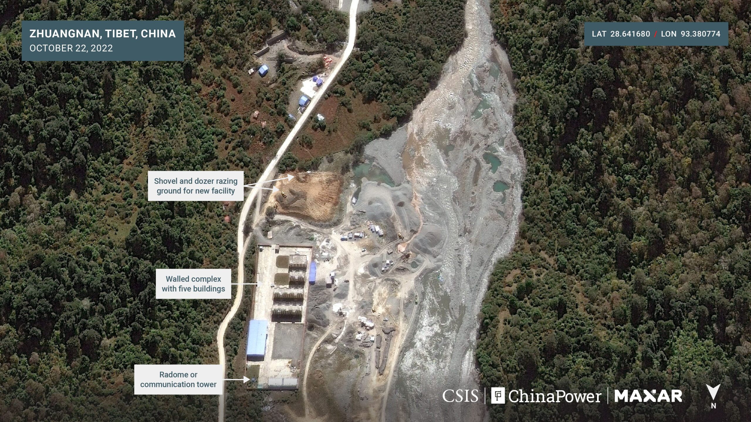
Just seven kilometers northwest of the LAC sits the border village of Zhuangnan (庄南), where a likely military or paramilitary facility has undergone significant work in recent years.
Historical satellite images show a walled complex with at least eleven buildings built there by 2019. By 2020, however, seven of the buildings were razed and new buildings were built.
Additional work was done there in the years that followed. Satellite imagery from October 22, 2022, shows an upgraded walled complex encircling four buildings that appear to be barracks, as well as another large building and a radome or communication tower.
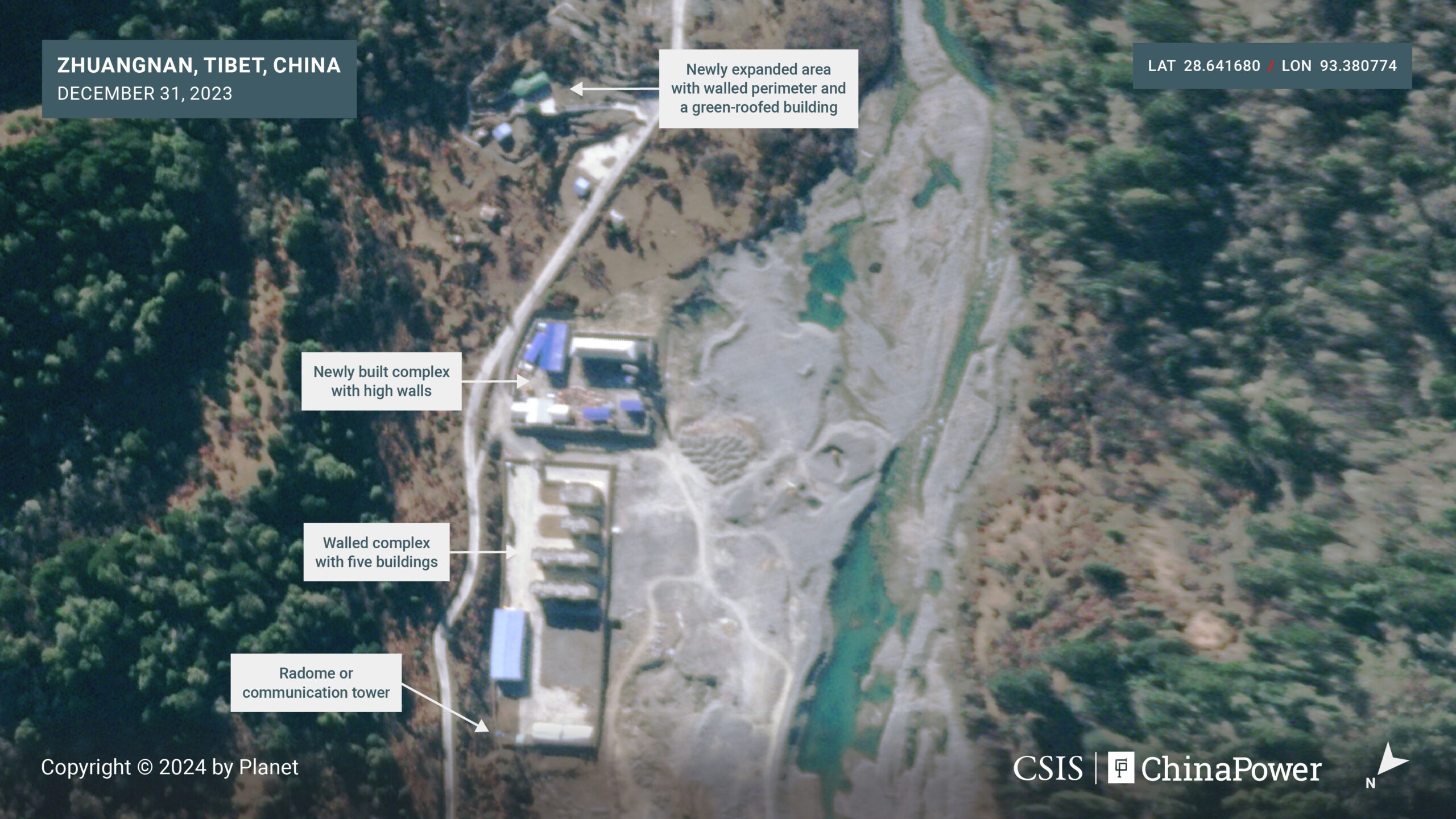
More recent images show two additional complexes being developed near the main complex since 2022. In an image from December 31, 2023, a new facility is visible due south of the main complex. It features high walls surrounding six buildings with vehicles throughout. Imagery also shows yet another new complex with a perimeter wall encircling a small, green-roofed building. Given its proximity to the nearby facilities, walled perimeter, and irregular shape, the green-roofed building is likely dedicated to observation or operational support.
The barracks, perimeter walls, and radome/communications tower located at these complexes indicate the likely presence of China’s military, the People’s Liberation Army (PLA). It is also possible these facilities are operated by the paramilitary People’s Armed Police (PAP). Under China’s Land Borders Law, these two forces share responsibility for defending China’s borders from armed attacks or other encroachments.2
While the exact purpose of these facilities is unclear, their position so close to the LAC suggests they may offer the PLA or PAP a vantage point for monitoring activities along this area of the border.
Expanded Village and Likely Military Activity at Majiduncun
Approximately 2 km north of Zhuangnan—and less than 10 km northwest of the disputed border, is the relatively large village Majiduncun (马及墩村), which has been significantly improved over the past two years.3
Majiduncun previously comprised a smaller number of buildings and two helipads, but by November 2018 the area started to be razed to make way for new building complexes. Imagery from October 22, 2022, shows village construction was still underway, with several of the new grey-roofed buildings to the north already complete.
Imagery captured about a year later, on November 8, 2023, shows the village’s new buildings externally completed, with well-paved roads throughout the area. Notably, the two existing helipads are still present. Given the region’s mountainous terrain, helipads play a key role in facilitating the swift movement of people, equipemnt, and supplies in the area, especially during emergencies.

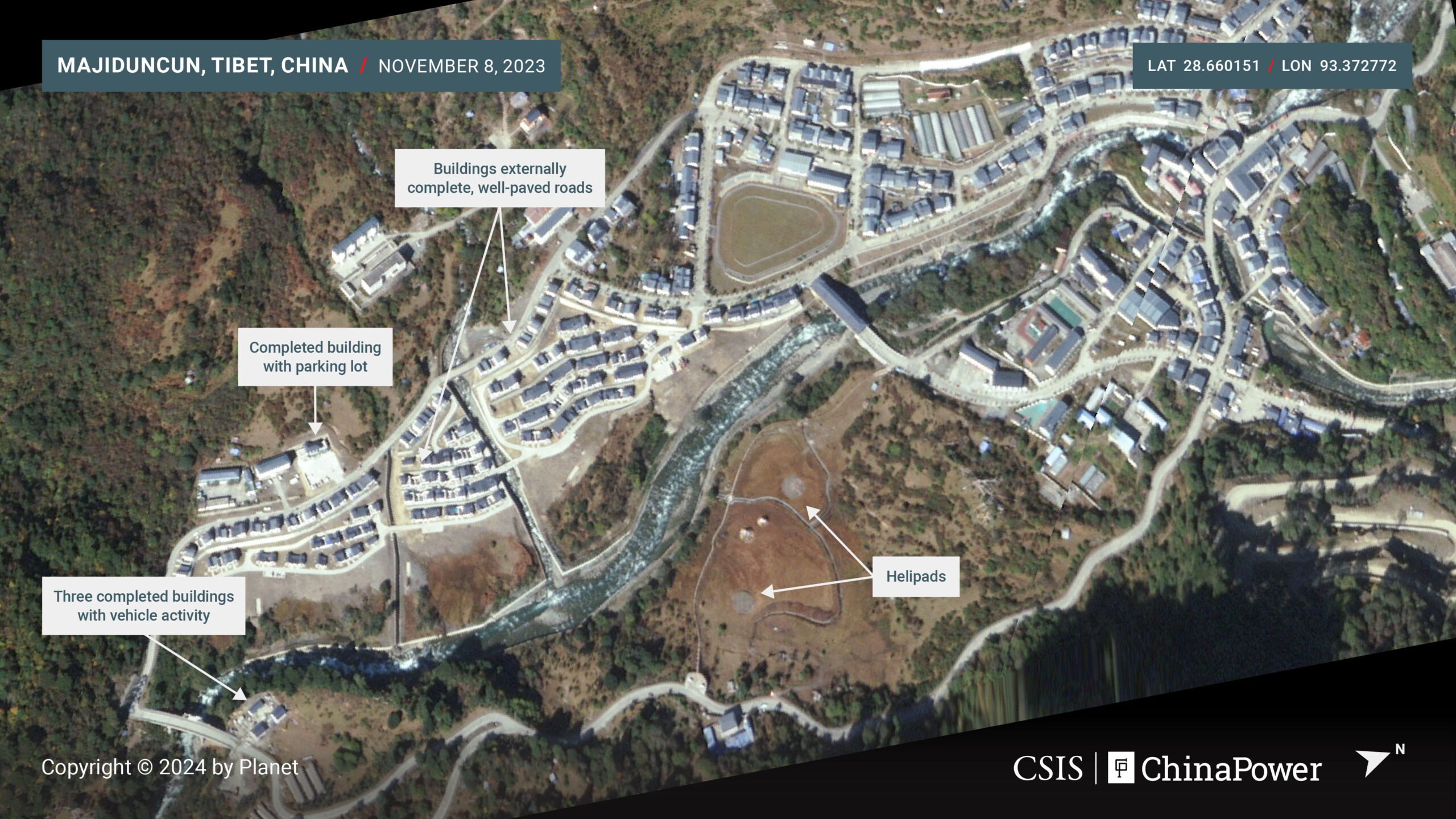
On the northern edge of the village is a likely PLA or PAP facility that shows signs of continued activity. The facility includes a gated entrance, a satellite dish, and changing numbers of likely military heavy trucks in the parking lot over the past year.

The presence of military or dual-use facilities is a common feature within xiaokang villages. China’s Land Borders Law codifies border defense into the responsibilities of border area governments, calling for them to “strengthen the construction of mass defense forces [群防队伍] to maintain border security.” Furthermore, a 2021 article in the official newspaper PLA Daily emphasizes the “need to strengthen the construction of border infrastructure and encourage people of all ethnic groups to root themselves in the border areas, guard the homeland, and build their hometowns” in this region.
This emphasis on leveraging civilian villages to support the military bears the hallmarks of China’s “military-civil fusion” (军民融合) strategy, which aims to fuse together China’s economic and military development to support overall national objectives.
In addition to building border villages, China has also been constructing and upgrading airfields, railways, and other dual-use infrastructure to enhance its military capabilities along its western frontiers. Explore our feature to learn more.
It is also indicative of China’s efforts to use gray zone tactics to advance its strategic and security interests in disputed areas while staying below the threshold of armed conflict. By building civilian villages, China can increase the population of remote border areas, adding legitimacy to its territorial claims. This simultaneously creates the necessary infrastructure to better support military and police forces, which, in turn, helps to protect local civilians from perceived threats across the border.
New Village at Yarao
Situated approximately 26 km northwest of the border is another example of one of China’s xiaokang villages, called Yarao (亚绕). Roughly 30 buildings were constructed at Yarao between 2018 and early 2022, but work there accelerated in 2022.
Satellite imagery shows that at least 65 new buildings of identical shape were built between March and November 2022. Workers also added a new road leading to two new helipads due east of the village.
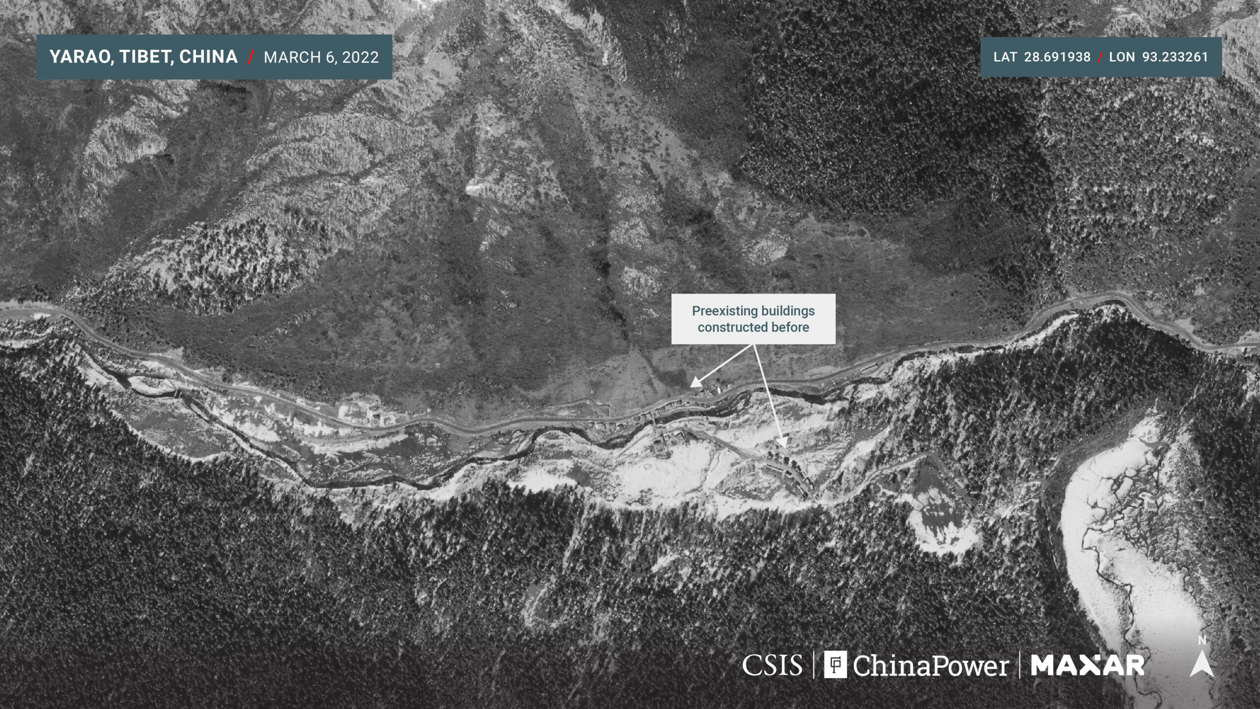

The images available in November show that some of the new buildings at Yarao were not yet roofed, but more recent imagery analyzed by the authors shows that the buildings were externally completed by December.
The speed of construction at Yarao is a testament to China’s capacity to rapidly build infrastructure to support new xiaokang villages. China’s progress is particularly impressive given the inhospitable terrain of the Himalayas. Yarao sits at a breathtaking 3,900 meters above sea level, where the thin air can pose health risks, and harsh temperatures and weather can create logistical challenges.

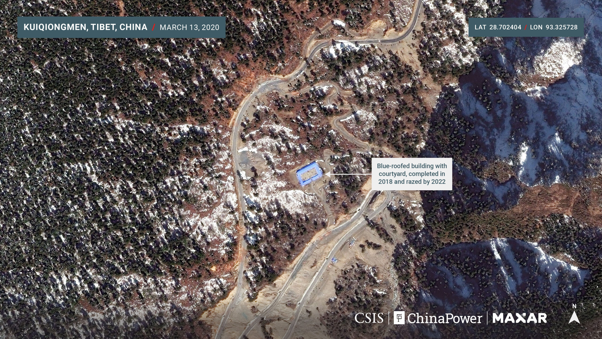
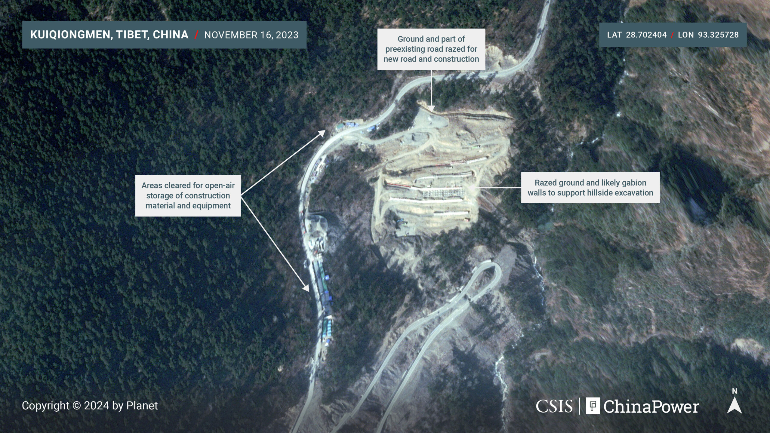
New Potential Military Outpost at Kuiqiongmen
Between these far-flung villages, China is constructing new roads and what may become small security outposts. One such potential location is visible near Kuiqiongmen (亏穷们), approximately halfway between Majiduncun and Yarao.
Satellite imagery from March 13, 2020, shows a winding road along a steep hillside more than 3,700 meters in elevation leading to a small, blue-roofed building with a courtyard.
The original building was externally completed in early 2018 and then razed sometime between March 2020 and March 2022. Satellite imagery captured on November 16, 2023, shows significant work underway to expand the grounds formerly occupied by the building. Visible in the image are construction vehicles, equipment, and likely gabion walls to support continued hillside excavation. Along the road to this construction site, areas were cleared for open-air storage of construction materials and equipment.
It is not yet clear what kind of facilities will be built here but given the location’s remoteness from other villages and its position on a hillside overlooking a valley, it is likely that this location could serve as a military or police outpost.
Conclusion
The four locations analyzed here comprise only a meager swath of the expansive disputed border. China has built hundreds of villages along the border in recent years, and it continues to expand and upgrade both civilian and military infrastructure in the area.
Satellite imagery analysis by ChinaPower reveals how China has invested in a significant, long-term military presence at other areas along the disputed China-India border. Explore our imagery and analysis to learn more.
China is not alone in developing infrastructure along the border. Alarmed by China’s border buildup, India also launched its own program to build villages in Arunachal Pradesh and other border states. However, China has demonstrated an enormous capacity to develop these regions, and India will find it challenging to keep pace with China.
China will continue developing these areas to support its strategic objectives. As it does, analysts should continue to observe China’s activities to stay informed about its evolving approach and capabilities in the region. 
Authors: Jennifer Jun is a project manager and research associate for satellite imagery analysis with the iDeas Lab and the Korea Chair at the Center for Strategic and International Studies (CSIS). Brian Hart is a fellow with the China Power Project at CSIS.
Additional Imagery Analysis: Joseph S. Bermudez Jr.
Design Support: William Taylor